29th May: Keswick – Caldbeck 29km
The weather forecast was full of doom – ‘You may struggle to stay upright at times’ – so it seemed sensible to take the low-level route, avoiding the summit of High Pike. I hadn’t actually measured that route but guesstimated it wouldn’t add too much. That prediction wouldn’t age well. After breakfast in Booth’s I set out in light rain to pick up a sandwich at Jan’s (very good) then headed towards the old station. There was no one much around as I plodded my way up Spoonygreen Lane round the back of Latrigg (which people seem to pronounce luh-TRIG not LAT-rigg, as if it were French). feeling rather boiled-in-the-bag in full waterproofs. There were only three cars in Gale Road car park, some people on Latrigg, some ahead of me on the path and, as I turned off below Lonscale Fell, some very misguided people heading towards Skiddaw. Mad.
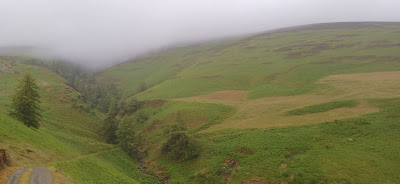 |
| Below Lonscale Fell |
It was pretty hideous going in the driving rain and low cloud over Glenderaterra Beck, although I was pleased the wind was at my back, as it was supposed to be all day (talking of predictions aging badly…) I caught and passed a couple of lads and then, towards Skiddaw House, a couple who might have been the father and daughter we saw at the ODG but, being swaddled up and not wanting to hang around, I didn’t quite confirm. Nonetheless we did agree between ourselves that low-level was the way to go today.
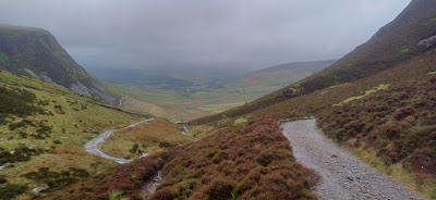
 |
| The view above Skiddaw House |
Just after I left them I came to a gate that was under at least half a foot of water, with no way round. I shuffled along a fence and swung the gate open, swooshing like a lock gate on a canal, and danced my way over some submerged rocks as quickly as I dared. I wondered about stopping to eat at Skiddaw House but wasn’t sure of the protocol so pushed on. Finally the rain was easing and some of the lower tops, Great Calva for instance, were free of cloud. It was still windy as the path had reached 480m, which seemed fairly high but is 180m short of the high-level route. Views opened up to the north-west, though Binsey was invisible. Dash Falls thundered down and it is disappointing there isn’t a good viewpoint of it from the path. A little further down I found a sheltered spot in an old quarry for some lunch.
 |
| Leaving the fells |
The weather, it seemed, had just been gathering its strength for the next onslaught. Heading north-west, the ‘southerly’ wind roared into my face, blasting me with heavy rain. I hunched myself over, like a scuttling figure from a Hiroshige painting, gripping the front of my hood to stop it blowing off. The waves of rain continued and I shouted curses against the weather. By a stone wall a sheep was hunkered down in the lee, its head pushed far down into the corner and its face a mask of glum suffering. ‘Same here, mate,’ I said.
 |
| Below Dash Falls |
There was some micro-navigation through farmland for a while, made more difficult when being lashed by a tempest, until I came to the road at Orthwaite. I could have done with more food but didn’t want to stop in those conditions so stomped off up the road. I finally got a chance to eat just near the little parking spot at Longlands, sitting on a low rock under a dripping tree. A couple of fit-looking blokes marched past. ‘Bit moist,’ one said. They were taking the low-level route too.
The path went east along the north edge of the fells, dipping and weaving between farmland, moorland and roads. There was an ‘interesting’ ford which would have flooded my boots had I not found a jump-able stretch of beck just downstream. The rain, thankfully, had stopped so I delayered somewhat and set to the task of grinding out the remaining kilometres.
 |
| Caldbeck in the distance |
Caldbeck, in view for a while, took an age to arrive and was a relief when it did, around 17:00. The Oddfellows Arms, where Jill was patiently waiting, was busy, hot and humid so we were soon on the road back to Keswick where it was a relief to fall into a hot shower and put on dry clothes. The day finished with a superb meal at Merienda (whole roast trout) and a few pints at the Dog and Gun.
30th May: Caldbeck – Carlisle 25km
The day looked fair, even if the ground was damp, but I knew well enough to keep the waterproofs in the bag. Breakfast was at Booth’s again, and so was lunch as we were driving back to Caldbeck for the final day. The journey through the moorland around Uldale was quite pleasant in decent weather.
 |
| River Caldew |
 |
| Many trees near Caldbeck |
The first part of my route took me through Caldbeck campsite and out of the National Park. There was a lot of woodland, full of birdsong, and no people at all. My legs felt all right, except for any incline when they reminded me of the distance I had done. My first crowd was a green lane full of ewes and lambs just below Sedbergham Hall. I stood to one side to let them nervously past but got bored of that and just squeezed along one side. They soon raced by as they were being chased by the shepherd in his pickup and his family on foot. Mrs Shepherd apologised as they had been delayed by one sheep getting stuck in the hedge. ‘They go everywhere they’re not supposed to.’
 |
| Ovine rush hour |
Beyond there I followed the River Caldew’s lazy wanderings through fields full of sheep and cows. Swallows skimmed across fields full of buttercups and sand martins danced over the river. The Bridge End Inn looked tempting but I had places to be. I should have gone in as I lost the path twice in Buckabank, arriving 10 minutes later about 10m from where I started. The path carried on through the attractive red stone buildings of Cowen’s toy stuffing (amongst other things) factory and into the busy Dalston.
 |
| Near Welton |
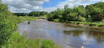 |
| River Caldew |
 |
| Following the path |
Earlier I had looked online to see if there was anything about path closures around the new Carlisle south bypass. ‘AI’ had said it was open, so naturally I was dubious. There were no signs as I joined the Caldew Cycleway at Dalston and no one wandering or cycling around offered any advice, so I carried on. The Cycleway proved to be tarmac all the way (8km), which was pretty relentless on feet and legs, stomping on and on. AI was right and the path curved its way around the works at the foot of the new road bridge over the Caldew. On and on I plodded. Clouds kept coming and going so the temperature swung between hot in the sun and cold in the wind, making it impossible to select the right clothing – either be too hot from time to time or be too cold. I tried both and went for ‘too cold’ which worked out quite well as it got warmer on the way into town.
 |
| New bridge over the River Caldew |
With an ache in my back and for a break from the constant stomping, I took a short rest just outside Carlisle before marching on again through the outskirts. As is typical, these seemed to go on much further than the map would suggest. Once I crossed the river my first goal was the West Walls Brewery tap, where Jill had just arrived. Some pre-celebration beers later, we walked into the centre to the market square. This was quite a challenge as the entire town was being dug up and half the roads were fenced off. I had to laugh at the ignominy that greeted my triumph as I finally reached the end of the Cumbria Way.
 |
| Carlisle Cathedral |
The week had had its challenging moments, particularly the suffer-fest on the way to Caldbeck, but the walk up Langdale and down Langstrath had been wonderful. Jill and I had had lots of laughs in the evening, and plenty of excellent drinks and food. The route was cleverly contrived, taking in a few sights and avoiding any monster climbs. The ‘Cumbria Way‘ signage was better outside the National Park, though often it was hand-painted by the landowner, although I wasn’t too worried about drifting around the ‘official’ route. Despite the weather I had thoroughly enjoyed the walk and came away feeling like I had added another layer of connection to the area.
 |
| Carlisle market place |


No comments:
Post a Comment