Day 1: Bradford to Burley-in-Wharfedale: 22.8km
The official start of the route is Bradford Cathedral but as I was taking the train over from Manchester, I started from Bradford Interchange. After a quick look at the city hall (which has an OS benchmark flush bracket in the wall), I made my way to the cathedral. From the outside it’s quite nondescript but I was pleasantly surprised by the interior where there is a splendid wooden-beamed ceiling with carved angels, and stained glass designed by William Morris & Co.
 |
| Bradford City Hall |
 |
| Bradford Cathedral |
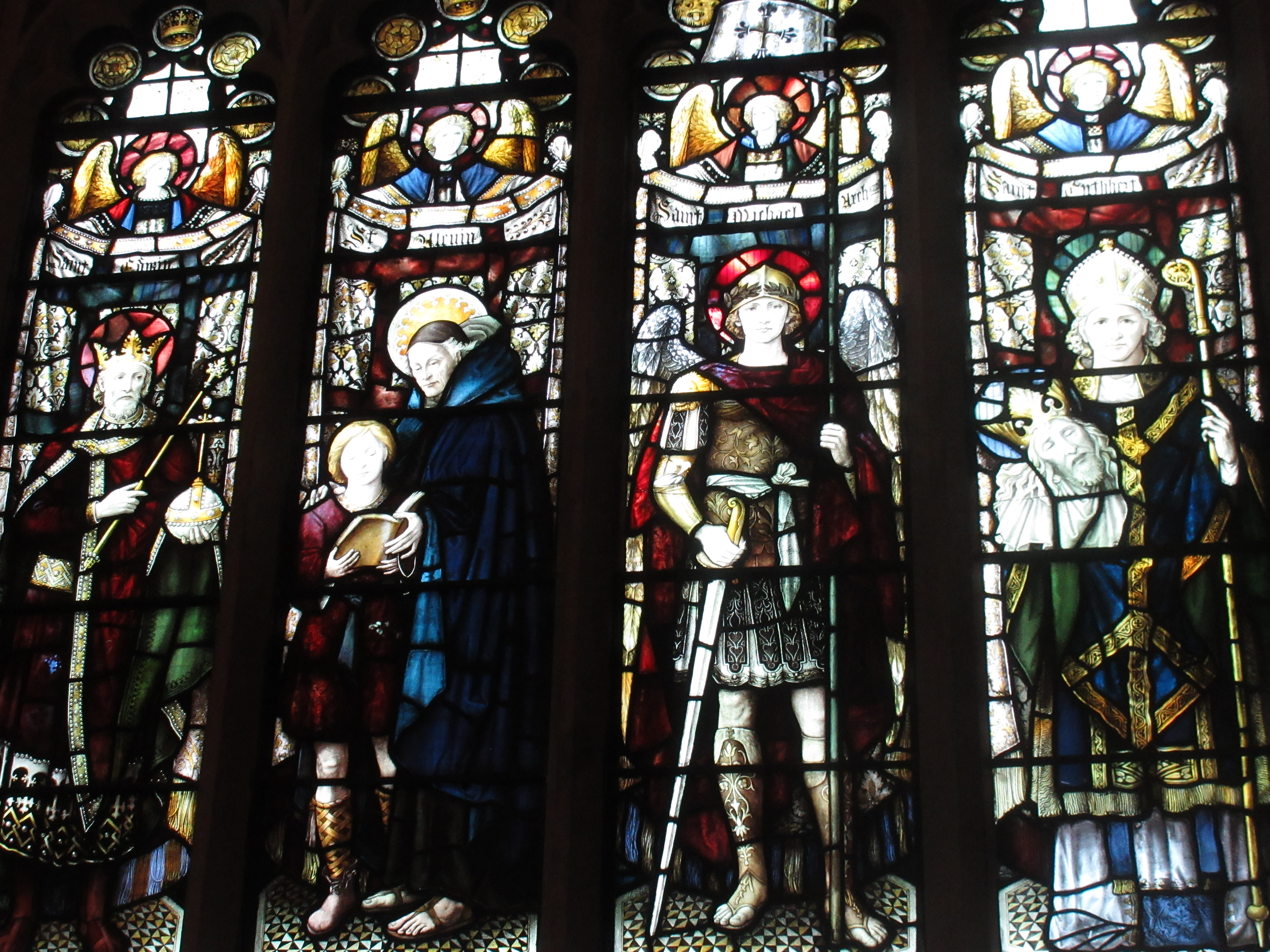 |
| William Morris & Co stained glass in Bradford Cathedral |
The weather was fine and mild as I walked some roads before ducking off through a confused series of ginnels, variously overgrown or lined with fly-tipped rubbish. There was a brief section of open parkland before I ended up thrashing through nettles, thistles and brambles – my GPS assuring me I was exactly on the path – and cursing having set out on the route.
It was a great relief to come to the Leeds – Liverpool Canal for a gentle stroll to Saltaire. Being close to the SALT Brewery, I couldn’t resist a quick diversion to the taproom. The terraced streets of Saltaire, commissioned by Sir Titus Salt, were being used for filming a period drama and I spotted Alan Bennett sitting with the production crew. Something to look out for on the telly.
 |
| Shipley Wharfe |
 |
| River Aire |
After that was a series of farm tracks and fields that had me checking the route frequently (I saw my first YHW waymarker after 16km) until coming to the open countryside of Hawksworth Moor on the shoulder of Ilkley Moor. As I was feeling the effort from carrying a heavy, multiday bag, I chose what I thought was the simplest route without checking the ‘official’ one and went via Hag Farm and Hag Farm Road into Burley, missing out the Hermit (apparently the late Richard Whiteley’s local). Along here there were more people out than I had seen since leaving Shipley, including kids coming home from school.
 |
| A rarely-spotted waymarker |
The walk through Burley seemed something of a drag until finally I got to the Red Lion to meet Jill who was giving me a lift. After a quick pint we drove up to the Hermit, which was rather nicer than the Lion, before heading to friends in nearby Menston for the night (yummy fish and chips from the Wetherby Whaler for tea).
Day 2: Burley-in-Wharfedale to Pateley Bridge: 29.8km
Forecasts suggested it was going to be a wet afternoon so I kept the waterproofs with me while dropping as much else with Jill who I would see later in the day. It was a relief to have a lighter bag on my back.
The route crosses Burley stepping stones but the flood watch website gave a river level reading that was higher than the crucial 0.17m (0.24m, I think) which would allow safe passage. The route was created by Burley Ramblers as a means of raising money for a bridge to be built alongside the stepping stones, a cause I was fully in support of that morning.
 |
| Fast-running River Wharfe at Ilkley |
Rather than the official diversion along the A65, I chose a countryside route to Ilkley, which was really nice in the bright morning sun. There was another clomp through town to Denton Bridge, noting the rushing River Wharfe, and an unpleasant walk along the busy Denton Road. This got better as I climbed through Denton and up into farmland, meeting some friendly, if noisy, pigs. Finally I was out on the moors again where my spirits always lift up, even if my feet were sinking into bogs and I was being harassed constantly by angry curlews.
 |
| Ivy House on Denton Moor |
 |
| Blubberhouses Church |
 |
| River Washburn |
It was hot now so I took off a layer. The immediate effect of this was for the wind to pick up but I battled on all the same. The climb up past Thruscross Reservoir along the road was a bit of a drag until I could cut across moorland. Here I was mobbed by curlews again and a particularly aggrieved lapwing who swooped within a couple of metres of me. I made my apologies and kept going as best I could.
 |
| Angry lapwing |
This was a quick, level stomp by the River Nidd with the odd muddy section. Just before the village, almost at the old station, the rain made its late appearance and it bucketed down. Despite being so close, I had to stop for a jacket and arrived at the Crown dripping. Thankfully it was a welcoming place with excellent hot showers, filling meals and a selection of decent beers. A good finish to the day.
Day 3: Pateley Bridge to Ripon: 26.2km
The ‘medium’ breakfast was perhaps ambitious, but at least I hadn’t gone for the ‘large’. It was sufficient enough that I didn’t feel like eating anything again until four hours later, despite my usual morning urge to snack.
 |
| River Nidd |
To begin with I retraced my route to Glasshouses and then carried on along the river to Smelthouses. I could see and hear tree surgeons at work up ahead and of course they were right on my path. After a quick shout they gave me permission to pass through into the Fell Beck valley. This was another delightful little wooded glen with a peaty stream chuckling over rocks below. A sign warned that because of ‘old age and climate change’ the owners had cancelled public liability insurance for the path and I entered at my own risk. Bear Grylls has nothing on me and I plunged on, clearly living to tell my tale on the other side. I’m not sure what the problem was.
 |
| Fell Beck |
The path finally started to climb up towards Brimham Rocks, making my knees protest for a while. It was only a short ascent to the top where I had a wander round the various gritstone formations. They reminded me somewhat of the Peak District’s edges, or the lumps you get in the Cairngorms (Barns of Bynack, say). When I was a kid, we had travelled over from York for a day out a couple of times, but I haven’t really been back since. There were a few people around so I didn’t stay long.
 |
| Brimham Rocks |
 |
| Studley Royal Deer Park |
 |
| Splendid chestnut tree |
The path followed the river over the ‘Seven Bridges’ (I only counted five) then climbed up again, getting a view of the top of Ripon Cathedral above and between the hedgerows, before coming back down at Hell Wath Nature Reserve. Clearly this is popular with the locals and a maze of paths cut across it. I navigated partly by instinct, partly by GPS. Sadly my route along the south side of the river was scuppered by a fence built right across the path (still a PROW on the OS maps). I had to retrace my steps and walk the final bit on tarmac. Kirkgate gave a nice approach to the Cathedral where I met Jill and my mum, who lives nearby. Time for celebratory photos, pints in the One-Eyed Rat and a pub meal.
 |
| Ripon Cathedral from Kirkgate |